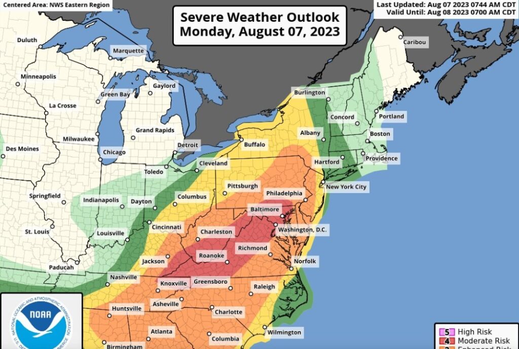
The East Coast of the United States is facing a high risk of severe thunderstorms on Monday, August 7, 2023, that could bring damaging winds, large hail and a few tornadoes to more than 50 million people from Georgia to New York. The storms are expected to develop in the late afternoon and evening hours, following a cold front that will end the heat wave that has gripped the region for the past week.

Level 4 risk for parts of Mid-Atlantic
The National Weather Service Storm Prediction Center (SPC) has issued a rare Level 4 out of 5 risk of severe storms for parts of the Mid-Atlantic, including Washington, D.C., Baltimore, Philadelphia and Harrisburg. This means that widespread severe storms are likely, with a high chance of long-lived, intense and widespread wind damage, as well as isolated large hail and tornadoes. The SPC warns that some of the storms could produce wind gusts up to 80 mph, which could cause widespread power outages and tree damage.
The SPC also highlights the possibility of a derecho, which is a long-lived line of storms that produces widespread and severe straight-line winds along its path. Derechos are notorious for causing extensive damage and travel disruptions across large areas. The last major derecho to affect the Mid-Atlantic was in June 2012, which killed 22 people and left millions without power.
The enhanced risk area also includes parts of Virginia, West Virginia, Maryland, Delaware, New Jersey and Pennsylvania, where severe storms are more probable than usual. The main threats in this area are damaging winds and large hail, but a few tornadoes cannot be ruled out.
Flash flooding possible from D.C. to New York City
In addition to the severe weather threat, the storms could also produce heavy rainfall that could lead to flash flooding in some areas. The National Weather Service has issued flash flood watches for parts of the Northeast, from Washington, D.C. to New York City and into parts of New England. The watches are in effect from Monday afternoon through Tuesday morning.
The weather service warns that some areas could receive 2 to 4 inches of rain in a short period of time, which could cause rapid rises in streams and creeks, as well as urban and poor drainage flooding. Some locations could see even higher amounts of rain if the storms move slowly or train over the same areas. Flash flooding is a dangerous situation that can occur with little or no warning. The weather service advises people to avoid driving through flooded roads and to seek higher ground if they encounter flooding.
Storms will end heat wave but not heat
The cold front that will trigger the storms will also bring relief from the oppressive heat that has been affecting the Northeast for the past week. Many cities have broken or tied records for high temperatures and consecutive days above 100 degrees. For example, Newark, New Jersey, hit 102 degrees for the fifth day in a row on Sunday, breaking the all-time record for consecutive days over 100. Boston surpassed its record at 100 degrees, Philadelphia broke its record at 99 degrees and Providence, Rhode Island, did the same at 98 degrees.
The cold front will lower the temperatures to more seasonable levels in the 80s for most of the Northeast by Tuesday. However, the humidity will remain high and the heat will not be gone for long. According to AccuWeather Meteorologist Brandon Buckingham, “Heat can build during the middle to late part of August in the Northeast and mid-Atlantic as many kids return to school. This can be accompanied by high humidity and a risk for thunderstorm activity.”
Meanwhile, the South will continue to deal with dangerously hot conditions this week, with excessive heat warnings and heat advisories in effect across the southern part of the country, from southeast California into Florida. Some cities could see triple-digit temperatures, such as Portland and Medford, Oregon; Fresno, California; San Antonio, Houston and Dallas; Tulsa, Oklahoma; Little Rock, Arkansas; and Shreveport, Louisiana. In Tennessee, Nashville is expected to hit 102 degrees on Monday, while Memphis is expected to reach 108 degrees.
How to stay safe during severe weather
Severe weather can pose a serious threat to life and property. The National Weather Service offers some tips on how to stay safe during severe thunderstorms:
- Stay informed: Monitor local media outlets or NOAA Weather Radio for updates on weather conditions and warnings. You can also check the SPC website for outlooks and watches.
- Have a plan: Know where to go and what to do if severe weather strikes. Identify a safe shelter in your home or workplace, such as a basement or an interior room away from windows. Have an emergency kit ready with essentials such as water, food, flashlight, batteries and first aid supplies.
- Act quickly: If you are under a severe thunderstorm warning or a tornado warning, seek shelter immediately. Do not wait until you see or hear the storm. If you are outdoors, find the nearest sturdy building or a low-lying area. If you are in a car, drive to the closest shelter or stay in the car with the seat belt on and your head down below the windows.
- Avoid hazards: Stay away from windows, doors and outside walls during a storm. Do not touch electrical equipment or corded phones. Avoid flooded roads and areas. Do not walk, swim or drive through flood waters. Turn around, don’t drown.


